IASPEI Cooperation for Better Understanding of the Earth
Download as PDF (3.6 MB)
Contents
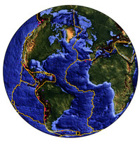
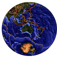
Seismicity of the Earth, 1964-1995, magnitudes greater than 5.1 (from E. R. Engdahl, R. D. van der Hilst, and R. D. Buland, Bulletin of the Seismological Society of America, Vol. 87, 1997), with tectonic plate boundaries superimposed (courtesy Lisa Gahagan, University of Texas Institute of Geophysics PLATES project). Interrupted boundaries and short boundary segments are locations at which recent data indicate the existence of a boundary but the details of its continuation are uncertain. Hypocenter depth intervals, kilometres, are 0Ð70 (red), 70Ð300 (green), and greater than 300 (purple). The large circles are major earthquakes, magnitude greater than 7.4. Figure prepared by Madeleine Zirbes, U. S. Geological Survey, National Earthquake Information Center.
Earthquakes have been a source of terror and wonder for as long as people have inhabited the Earth: terror because these unexpected, sudden-onset events are capable of producing many casualties among the local population and massive destruction of property; wonder because people are awestruck by the forces of nature that suddenly disrupt the environment and alter the surface of the planet. Earthquakes are one of the major natural hazards threatening life, property, and economic well-being in many nations. Death tolls from major events are staggering: 255,000 in Tangshan, China in 1976; 10,000 in Mexico City in 1985. The economic loss in the 1995 Kobe, Japan, earthquake was more than US$100 billion. Nations striving for full economic development may find the investments and progress of decades wiped out in a few minutes.
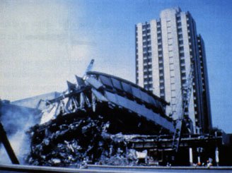
Contrast in performance of well-designed and poorly designed or constructed buildings, Mexico City, September, 1985 . Many tall concrete structures, designed to meet the building code, performed well in the midst of severe damage to other structures. Excellent earthquake engineering and construction based on up-to-date earthquake hazard assessments can reduce the catastrophic effects of major earthquakes in urban areas. (Photograph credit: E. V. Leyendecker, U. S. Geological Survey. Photograph provided by the National Geophysical Data Center, U. S. National Oceanic and Atmospheric Administration.) Inquiring minds have long sought to understand the processes responsible for this violent activity. The sites of the earliest recorded civilizations, the eastern Mediterranean and the Middle East, China, and Japan, are also the sites of frequent, often damaging earthquakes. The ancient official records of towns and villages and the earliest literature include accounts of earthquakes, what they had done, and speculation about their causes. The great Lisbon earthquake of 1755 did much to stimulate the scientific study of earthquakes in Europe. Much of the early work in Europe and Asia concentrated on documenting and mapping the distribution of effects, including damage to buildings. Intensity scales or their equivalent were born. The ever-increasing density of populations in places subject to earthquakes and the vulnerability of the lifelines (transportation, communications, water supply, energy supply) on which modern societies depend for functioning, even survival, have made the need to understand earthquakes and to mitigate earthquake disasters more pressing than ever.
In the later part of the 19th century a number of events thrust seismology into its modern era. The theories of elasticity and of waves in solid and fluid media were brought to a high level by physicists and applied mathematicians who were interested in problems apparently far-removed from earthquakes. Seismographs capable of making permanent, timed records of the ground-motion waveforms were developed and deployed for local and regional observations. Next, a teleseismic recording of an earthquake was recognized as such in 1889, when an event in Japan was recorded in Germany. This observation was accompanied immediately by the recognition that a recording of waves that had traversed a long path through the Earth's interior carried valuable information about the properties of the materials through which the waves had travelled. This led to the call, in 1895, for the establishment of a worldwide network of seismograph stations as a means of collecting data for the study of the Earth's deep internal structure. Ever since, the acquisition and analysis of data in order to locate earthquakes and study the physics of the seismogenic process have been linked to the study of the physics of the Earth's interior.
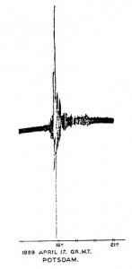
The first signal recognized as coming from a distant earthquake was identified by E. von Rebeur-*Paschwitz *in 1889. The waveform, recorded on a sensitive horizontal pendulum at the Potsdam Observatory in Germany, was generated by an earthquake in Japan. The realization that strong earthquakes could be recorded at great distances helped open the modern era of seismology and physics of the Earth's interior. (From Nature, Vol. 40, 1889.) Seismology and the physics of the Earth's interior were thus established as disciplines requiring international cooperation. In the late 19th and early 20th centuries national and regional scientific societies devoted to the advancement of seismology were created in Japan, Europe, and North America. Seismology was one of the original six Sections of the International Union of Geodesy and Geophysics (IUGG) when it was created in 1919 as one of the first three scientific unions established under the aegis of what later was named the International Council of Scientific Unions (ICSU). The term "Sections" was changed to Associations in 1933. Thus, the International Association of Seismology and Physics of the Earth's Interior (IASPEI), the title adopted in 1951, was born and is now one of the seven Associations that together constitute the IUGG. An excellent summary of the early history of international seismology and the creation of IASPEI is provided by J. P. Rothé in the Bulletin of the Seismological Society of America, Vol. 71, pp. 905-923, 1981.
The organization of IASPEI as an Association of IUGG is a powerful stimulus for international and interdisciplinary cooperation with all of the relevant geophysical sciences, cooperation recognized as essential for optimal progress in understanding the Earth as a complex physical-chemical system.
How IASPEI is Organized to Achieve its Objectives
As set forth in its statutes, the primary objectives of IASPEI fall into three categories:
- Promotion of the scientific study of problems related to earthquakes and other seismic sources, the propagation of seismic waves, and the Earth's internal structure, properties, and processes.
- Initiation and coordination of the conduct of research and of scientific exchanges and discussions that are dependent on cooperation among a number of countries.
- Facilitation of research and education in basic and applied seismology, especially in countries that are in the process of working towards full scientific development.
To achieve these objectives, IASPEI has developed an administrative and management structure based on a Bureau consisting of the President, First and Second Vice-Presidents, and the Secretary-General, and an Executive Committee made up of the Bureau and five additional Members. These officers are elected by the delegates of the Member Countries for four-year terms at IASPEI Assemblies held in conjunction with the General Assemblies of IUGG. The Executive Committee determines the policies of IASPEI; the Bureau implements these policies and manages the affairs of the organization.
The scientific work of IASPEI on specific topics is carried out through a number of commissions, subcommissions, committees and working groups. These operational groups are formed to meet the recognized needs of seismology and the physics of the Earth's interior, in particular as new and exciting scientific problems emerge, and are disbanded when their work is completed. Some topics require continuing attention, and the corresponding commissions have a long lifetime. Each commission or other research group is responsible for initiating, coordinating, and reporting on their research programs and progress. Much of the program at the scientific assemblies of IASPEI is formed from symposia and workshops planned and convened by these units.
In addition to its commissions devoted to specific scientific topics, IASPEI also supports commissions and committees to work on general needs of the discipline or to promote research and scientific discourse in specific geographic regions. IASPEI also participates in the work of a number of IUGG Inter-Association Commissions and, through IUGG, with the International Union of Geological Sciences, in the Inter-Union Commission on the Lithosphere (ICL).
Several international organizations and programs that are either independent entities or sponsored by other bodies have also been given commission status in IASPEI. This implies that, although these are not creations of IASPEI, they enjoy the Association's vigorous cooperation and support, similar to that given to its own commissions.
Details of the IASPEI administrative structure and of the organization if its commissions and committees may be found on the IASPEI home page on the World Wide Web.
The Scientific Programs of IASPEI
The scientific work of IASPEI may be categorized under a number of major topics. A description of these and the roles of the commissions and other operational groups in advancing the corresponding research and dissemination of knowledge follows.
Data Acquisition, Analysis, and Dissemination
Seismology has its roots in observations of earthquakes and earthquake-generated ground motion. The worldwide system of seismograph stations envisioned by the pioneers of the science is now a reality, a reality that is frequently upgraded and expanded as technology improves. A global system of broadband seismographs with high dynamic range is in place. This is supplemented by many regional and local networks capable of high-resolution monitoring of the frequent smaller earthquakes in seismically active places. However, all of these high-quality data are of little value until they have been brought together for analysis and the results of these primary analyses made available to all researchers and users of seismological information. This requires well-equipped data centers that can carry out the determination of the times, locations, magnitudes, and other general characteristics of the events; archive the results of these analyses in accessible form; and provide a mechanism by which these results and the original data are distributed. Through commissions and working groups IASPEI has played an essential role in the promotion of proper data management and the formulation of standards for data treatment. Looking toward the 21st Century, the primary IASPEI emphasis in evaluating new approaches to acquiring, processing, and distributing seismological data is the automatic performance of traditional tasks in as close to real time as current technology permits.
The Commission on Practice
The Commission on Practice advises national and international seismological reporting agencies and coordinates their work. The commission also cooperates with international programs, such as the International Seismological Observing Period (ISOP), the Global Seismic Hazards Assessment Program (GSHAP), and the International Decade for Natural Disaster Reduction (IDNDR), which are described more fully below. Also, among its tasks is advising the Executive Committee of the International Seismological Centre (ISC). Eight Working Groups of the Commission focus on specific problem areas, techniques, and tools. These range from the Manual of Seismic Observatory Practice to Magnitude Calibrating Functions and Digital Seismogram Interpretation.
"The Commission on Practice supports the work of various other academic and governmental groups engaged in the determination of optimal methods for estimating and reporting seismic source parameters." Stuart A. Sipkin (USA)
The working group on digital seismogram interpretation, as reported by Axel Plesinger (Czech Republic), has cooperated with ISOP (see below) in the completion of software packages and manuals for seismological data preprocessing, computation of ray synthetic seismograms, and inversion of seismograph calibration responses. The intention is that these products will be easily available to researchers.
In 1988, IASPEI established a Working Group on Personal Computers under the Commission to promote the production and distribution of seismological software for use on personal computers, thereby bringing the power of electronic computation to institutions not able to acquire larger machines. Under the auspices of this Working Group and in collaboration with the Seismological Society of America (SSA), a series of carefully reviewed and tested seismological software volumes for IBM-compatible personal computers is being published, edited by W. H. K. Lee (United States), J. C. Lahr (United States), and F. Scherbaum (Germany). Both executable versions and source code of this IASPEI Seismological Software Library (SSL) are available for purchase at a nominal cost through the SSA.
To complement the software library, the Working Group formed an IASPEI PC Shareware Library (PCSL) under the editorship of M. Garcia-Fernandez (Spain). The main objective is to provide fast and wide distribution of geophysical software. Programs in PCSL, while not critically reviewed, can be shared freely. The library covers different seismological applications and utilities from earthquake location to expert systems for earthquake prediction. The diskettes are distributed (for the cost of disk duplication) at scientific meetings or by mail.
The Joint Subcommission on Earthquake Algorithms (joint with the Commission on Wave Propagation) was created to follow and publicize computer code developments suited to wider use in seismological practice in the areas of regional structure, earthquake location, and quantification of the seismic source. To this end, the joint subcommission has organized regional workshops, been active in international cooperative programs in developing countries, and promoted the distribution of advanced seismological algorithms.
The Federation of Digital Broadband Seismograph Networks
The Federation of Digital Broadband Seismograph Networks (FDSN) is an independent international organization affiliated with (and with commission status in) IASPEI. The FDSN was formed in 1986, at a time when several nations were deploying regional or global networks of state-of-the-art seismographs. Working groups of FDSN provide forums for developing common minimum standards for seismographs and recording characteristics, for developing standards for quality control and procedures for archiving and exchanging data among component networks, and for coordinating the siting of additional stations in locations that will provide optimum global coverage. A working group on instrumentation has proposed that the scientific value of stations be improved by co-locating seismographs with other geophysical sensors to form true geophysical observatories.
"Development of a global system of digital very broadband seismographs with uniform optimum characteristics such as resolution and dynamic range is a long-term goal of the Federation. Such a system should be able to record essentially all teleseismic signals. Its immediate goal has been the global deployment of instrumentation that is able to record at least the range of signals accessible with standard (WWSSN) short- and long-period seismographs." Jean-Paul Montagner (France)
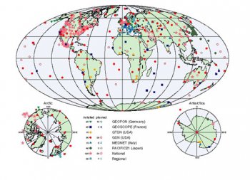
The distribution of global, national, and regional networks of digital, broadband seismograph stations, according to the inventory complied by the FDSN Working Group on Siting Plans, as of April, 1996. (Figure prepared by Robert Woodward, U. S. Geological Survey, Albuquerque Seismological Laboratory.)
The International Ocean Network
The International Ocean Network (ION), which also has commission status within IASPEI, seeks to establish permanent seismic observatories in the deep ocean. The primary purpose is to compensate for the limited sampling of the Earth's interior that is possible when using only land-based stations. In addition, active processes in selected sea-bottom settings can be adequately monitored. Seafloor seismic observations are also necessary to expand from using controlled sources for research on suboceanic structure to using teleseismic earthquakes. Geodetic measurements on the seafloor, an important adjunct to seismic monitoring, have been difficult but GPS-acoustic seafloor benchmarks are now possible with centimeter accuracy. Tilt measurements with microradian accuracy have been made in the eastern Pacific.
"Low-power digital recording systems make such a deep ocean network possible. ION is facilitating cooperation in the development of critical elements of the observing systems, standardization of those elements to allow shared maintenance, development of common plans for the use of resources such as provided by the Ocean Drilling Program, timely exchange of data, and coordination of siting plans." Kiyoshi Suyehiro (Japan)
Seafloor observatories, once established, could share common resources to measure a variety of parameters ranging from visual images and bottom currents to both episodic and long-term processes. Such observatories are now within the reach of current geo- and biosensor technology. Two successful early efforts were the 1989 Japan Sea borehole and the 1992 Mid-Atlantic Ocean borehole/seafloor observations. Future efforts hinge on re-use of transoceanic telecommunication cables, possible deployment of a new cable, and developments of new instruments.
The Physics of Earthquakes and Seismic Wave Propagation
The physical basis of seismology and the physics of the Earth's interior resides in condensed matter physics, continuum mechanics, fracture mechanics, and wave propagation in solid and fluid media. IASPEI and several sister Associations in IUGG vigorously promote research in the applications of these areas of basic physics to understanding the Earth.
Subcommission of the Commission on Earthquake Hazard and Prediction
Modeling the Earthquake Source is the charge to a Subcommission of the Commission on Earthquake Hazard and Prediction. The long-term goal is to construct a quantitative physical model for the entire earthquake process including tectonic stress accumulation, nucleation of rupture, and the dynamics of the subsequent rupture propagation and cessation. Advances in both observations and computer simulations are needed to accomplish this goal. Within the current focus of this research, one key is the determination of the critical stress that causes the fracture or yield of rock in the source volume of the earthquake. Recent advances in observations and the theory of seismogenesis provide clear seismic evidence for earthquake nucleation phases. Analysis of seismic waveform data has sought a relation between the duration of the nucleation phase and the seismic moment of an earthquake. Determination of the appropriate friction law for fault slip and the factors affecting the distribution of slip or moment release on the rupture surface are other subjects of active investigation. Another important issue is the physical interpretation of the spatial and temporal distribution of aftershocks, one of the most frequently observed effects of moderate to strong earthquakes. Still another question is whether earthquakes can be triggered by natural processes that affect regional stress and strain distributions.
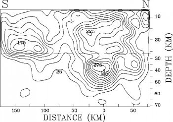
The distribution of slip on the fault during the March 3, 1985 earthquake in central Chile. The fault slip (cm) was computed by inversion of body-wave, surface-wave, and strong-motion waveforms. The slip is contoured at 25-cm intervals as of 14 seconds after the passage of a rupture front propagating at 3 km/sec from the hypocenter (labeled MS). The dashed line marks where the fault dip changes from 15° to 30°. (From C. Mendoza, S. Hartzell, and T. Monfret, Bulletin of the Seismological Society of America, Vol. 84, 1994.)
The Commission on Wave Propagation
The Commission on Wave Propagation is concerned with the theory of wave propagation in earth materials, which is the basis for the extraction and interpretation of the information contained in recordings of ground motion. Wave propagation theory, a specialized topic of applied mathematics, is a discipline important to researchers of the solid earth (elastic and electromagnetic waves), as well as to those who study the atmosphere and oceans (gravity waves, acoustics, and electromagnetics). The development of approaches to seismic modeling and interpretation problems in complex, interrelated earth structures requires intensive computation and has benefited greatly from advances in computer technology. The Commission is an umbrella organization that fosters communication and collaboration among investigators with diverse interests while emphasizing the solution of integrated problems.
"What distinguishes seismology is the complexity of the Earth and the wide range of interacting scales over which seismic wave propagation effects need to be studied. This challenge brings to seismology researchers with diverse backgrounds and interests which range from the very theoretical to the very practical. A vigorous discussion about the basic physics of earth structures such as subduction zones, continental roots and mantle plumes involving researchers with different approaches should provide a useful guiding influence as such difficult problems are tackled." Colin Thomson (Canada)
During the early decades of seismology, data were interpreted on the basis of a model of the Earth in which the materials were assumed to be elastically isotropic and physical properties were assumed to vary only with depth. The quality of modern data and the state of the applicable theory have now advanced to the point that the use of these simplifying assumptions is neither necessary nor acceptable. The properties of materials in the real Earth vary in three dimensions and are anisotropic in part. Furthermore, lateral structure and seismic anisotropy may be linked in fundamental ways, so that maps and sections showing structure may indicate where anisotropy might exist and, conversely, mapped distributions of anisotropy offer a key to understanding geodynamic stresses and petrological structure in three dimensions. The Subcommission on Heterogeneity is concerned with the effects on wave propagation of departures from the standard radial models of the Earth, and the Subcommission on Anisotropy with the effects of departures from the assumption of a simple isotropic medium through which seismic waves travel.
Earthquake Hazard Analysis, Earthquake Prediction, and the Interface with Earthquake Engineering
The Commission on Earthquake Hazard and Prediction
An important practical application of improved knowledge of earthquakes is the estimation of the probability of occurrence of an earthquake of given magnitude at a selected place, in both the long and the short term. Substantial progress has been made on the development of methods for earthquake hazard analysis on time scales of a few decades. The prediction of specific earthquakes on time scales from a few years to a few days has proven to be a difficult problem, but research continues in a number of countries. The organization and implementation of IASPEI efforts in this subject of great significance to society is the responsibility of The Commission on Earthquake Hazard and Prediction, which functions through four subcommissions. (Its subcommission on modeling the earthquake source has been described previously.)
The Subcommission on Earthquake Prediction
The Subcommission on Earthquake Prediction is faced with a fundamental issue, the inherent predictability of earthquakes. Chen Yong (China) points out that understanding this fundamental issue will guide decisions about future research. "Prediction" implies the stipulation of the time, place, and magnitude of a specific future event, with estimates of the uncertainties of each of these parameters. If earthquakes are not predictable to the extent that such predictions are reliable for practical, as well as scientific, purposes, it is reasonable to ask whether further efforts and more resources should be devoted to the search for prediction methods. There is evidence, on the other hand, that at least some earthquakes in some tectonic regimes are predictable with useful accuracy of time and space. So the most relevant question becomes "Are we sure our research is going in the right direction?" The full implications for the predictability of earthquakes of recent developments in chaos theory, self-criticality, and nonlinear continuum mechanics are still to be determined.
This subcommission is charged with defining the categories of scientific information thought necessary to predict earthquakes and evaluate the reliability of various suggested precursors. It provides forums, through symposia and workshops, for the exchange of experience and ideas among researchers. If and when proposed precursors are adequately defined and their reliability and reproducibility have been sufficiently established, the basis of the precursors can be sought in our knowledge of the physics of the earthquake process. Other working groups under the subcommission focus on crustal deformations, seismicity patterns, interdisciplinary approaches to prediction, and anomalies related to rock properties.
The Subcommission on Earthquake Hazard and Risk
The Subcommission on Earthquake Hazard and Risk is charged with the advancement of methods to estimate seismic hazard or risk and the evaluation of proposed methodologies. This subject is being pursued actively in many countries that experience damaging earthquakes. Hazard analysis requires
- characterization of the seismic sources that can be expected to affect a selected place, in terms of locations, magnitudes, and frequency of occurrence of potentially damaging earthquakes;
- knowledge of the attenuation of ground motion with distance from the source to the site;
- knowledge of the local geology for site-specific assessments.
Risk analysis yields probabilistic estimates of the losses of property and lives from earthquakes to be expected at a site and is essentially a convolution of the hazard estimates and the distribution of structures, facilities, and people. The subcommission functions through five working groups: seismic risk, advanced geoinformation technologies, seismic hazard assessment techniques, effects of surface geology, and induced seismicity.
A basic tool of risk assessment is the development of earthquake scenarios, such as modeling what will happen if an event such as the 1906 California earthquake were to recur. The development of predictions of ground motion at a site as a function of source magnitude and distance may yield to current efforts to develop attenuation relations using recent earthquake data, according to Vladimir Schenk (Czech Republic). Attenuation vs. distance relations vary strongly from region to region. Other current work includes estimating both linear and nonlinear site-response effects, determining spatial variations from array data, and using numerical simulation. Advanced geoinformation technologies are also being exploited for earthquake hazard and risk assessment.
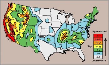
A simplified seismic hazard map for the conterminous United States. Peak horizontal accelerations, in percent of g, with a 10 percent probability of being exceeded in 50 years are displayed. (Courtesy Arthur Frankel, United States Geological Survey.)
The Subcommission on Strong Motion Seismology
The Subcommission on Strong Motion Seismology is concerned with the significance and engineering implications of different measures of strong motion such as displacement, velocity, or acceleration. Strong ground-motion measurements provide the observational basis for many of the studies underway by the other Subcommissions and Working Groups, described below. Ground motion and site effects in different tectonic regions are being explored.
Commission for the International Decade for Natural Disaster Reduction
IASPEI's Commission for the International Decade for Natural Disaster Reduction, an entity distinct from the Hazard and Prediction Commission, was created to guide the Association's participation in the International Decade for Natural Disaster Reduction (IDNDR), established by the United Nations for the 1990s. A key aim of the IDNDR is to bring the best of contemporary scientific knowledge, technology, and disaster mitigation methods to bear on the abatement of the effects of catastrophic natural events. With regard to earthquakes, the approach has been to unify research and educational activities by seismologists, geophysicists, structural engineers, geotechnical engineers, economists, and others involved in risk assessment, mitigation planning and their applications. The ultimate goal of efforts to minimize earthquake vulnerability is the reduction of the loss of life, number of injuries, and economic devastation of earthquakes.
"Some crucial gaps in seismological knowledge have been filled. Much more understanding has been gained about earth-quake processes and occurrence, seismic wave propagation, and the variability of shaking intensity. In seismically prone countries around the world, seismographic recording has increased and recording networks have been upgraded." Bruce Bolt (USA), reporting on progress through the first half of the IDNDR.
The proposed goals and activities of IASPEI related to the IDNDR were defined in the report "Minimizing Earthquake Vulnerability." This program document provides information about needed research on seismic hazards: ground-shaking, landslides, faulting, liquefaction, and tsunamis. The IASPEI/IDNDR program was adopted as a demonstration project by the United Nations Scientific and Technical Committee. One task of the Commission is to compile, in both special volumes and digital form, information related to destructive earthquakes. The compilation of the 1988 Spitak (Armenia) earthquake data base was the first such IASPEI volume. A later volume contains selected papers from the 2nd International Conference on Continental Earthquakes, which was held in Beijing. In another IASPEI/IDNDR effort, a worldwide map of future earthquake losses is being developed by a working group in collaboration with organizations representing engineers and economists. Among the other documents available to user communities, such as earthquake engineers and legislative planners, are: "Continental Collision Zone Earthquakes and Seismic Hazard Reduction," and "The Practice of Seismic Hazard Assessment."
Efforts are underway to develop better documentary material on seismic risk reduction in the form of a series of technical manuals. These manuals, to be developed from the content of workshops, will focus on items of practical interest, especially to earthquake engineers, the construction industry, land-use planners, the insurance industry, and local and national governments around the world The emphasis will be on those developing countries where the earthquake risk is particularly severe.
The Global Seismic Hazard Assessment Program
The Global Seismic Hazard Assessment Program (GSHAP), an international demonstration project of IDNDR, was recently completed as a successful collaborative effort in which IASPEI participated. Initiated by the International Lithosphere Program (ILP) and endorsed and supported by IASPEI, GSHAP embodied many of the strategies and policies defined by the IDNDR. Its primary goal was to promote a regionally coordinated, homogeneous approach to hazard evaluation, in order to provide the information needed by governmental decision makers and engineers for land-use planning and improved structural design and construction. The GSHAP program, an effort to minimize loss of life, property damage and social and economic disruption caused by earthquakes, was coordinated at a global level but implemented at regional and local levels through regional centers. Under GSHAP, seismic hazard assessment developments were undertaken in the East African Rift countries and other African locations, south and central Asia, Latin America and the Caribbean, in addition to northern and central Europe. For example, CERESIS (Regional Center for Seismology in South America) has produced a reference hazard map for all of South America. The European Seismological Commission coordinated activities in the larger European-Mediterranean area, and a network of regional programs covers Canada, the United States, Mexico and Central America, and the Caribbean.
System for Technology Exchange for Natural Disasters
An information exchange program known as the System for Technology Exchange for Natural Disasters (STEND) is aimed at increasing awareness, particularly in developing countries, of available technology. STEND is an IDNDR demonstration project of the World Meteorological Organization. It currently provides information on hydrology, seismology, volcanology and related engineering topics. The STEND Advisory Committee, which includes representatives of IASPEI, IAVCEI, and GSHAP, hopes to extend STEND to include hazards of meteorology, landslides, and tsunamis. The STEND Reference Manual provides descriptions of instruments, software or publications in the fields of data acquisition, interpretation, analysis, and methodologies.
The need for an interface of seismology with earthquake engineering is made clear by the emphasis of many of the efforts of IASPEI's Commission on Earthquake Hazard and Prediction and of the Commission for the IDNDR. Working groups of the Commission on Hazard and Prediction provide this interface from the earth sciences perspective. The need to make available the results of seismological research in a form useful to the engineering practitioner is widely recognized. The Working Group on Seismic Hazard Assessment joined with the European Seismological Commission to compile a monograph, "The Practice of Seismic Hazard Assessment." A unique compendium of methods and results, this monograph presents data from 59 nations. In another collaborative project, this working group is cooperating with the International Association of Earthquake Engineers (IAEE) to develop a world map of estimated future earthquake losses.
"Records of strong ground-motion provide information that is essential for earthquake engineering and earthquake hazard assessment. Questions we now study include: What can be learned from site effects in recent great earthquakes? How can attenuation of ground motion with distance be estimated?" Xie Li-Li (China)
The Working Group on the Effects of Surface Geology on Seismic Motion, acting as joint sponsor with the IAEE, has promoted a set of "blind" prediction experiments at Turkey Flat, California and Ashigara Valley, Japan. In these experiments, participants used their preferred methods to predict the ground motion at one or more test sites, given the relevant geological/geotechnical properties, taking the measured motion at a reference site as input. The observed ground motion at each test site was not disclosed until the predictions were submitted. The results of the early experiments demonstrate that a great deal is yet to be learned about the prediction of strong ground motion, even when the relevant background information is known. The working group is cooperating with both "open" and "blind" experiments and intends to prepare a state-of-the-art document that sets forth the science as well as the technology for evaluating the effects of surface geology on strong ground motion.
The Working Group on Earthquake Risk and Loss Assessment chose a test case to evaluate methods for assessment of risk and loss from future earthquakes. The test site was the northern Gulf of Eilat/Aqaba, bordering Egypt, Saudi Arabia, Jordan, and Israel. Among the tasks was the development of new correlation functions between ground motion parameters and structural damage. The ultimate goal is to develop seismic hazard, structural vulnerability, and damage cost functions expressed in terms of instrumental measures of ground motion, such as peak accelerations or velocities, or values of response spectra at selected frequencies.
Earth Structure and the Physics of the Earth's Interior
Recordings of seismic waves provide the most comprehensive data set and the highest available spatial resolution for the investigation of the structure of the interior of the Earth and for constraining the properties of the materials at depth. Seismic data are combined with the findings of other disciplines that fall within the scope of IASPEI. For example, the thermal physics of the Earth and laboratory studies of rock physics and chemistry provide the basis for models of the Earth and its dynamic processes. There are always questions of the uniqueness of Earth models derived from geophysical data. Nevertheless, currently accepted models of the Earth's interior, on scales from local to global, are based primarily on data provided by seismograms from earthquakes, large underground explosions, and a variety of controlled sources of seismic waves, combined with observations of the gravity and magnetic fields and heat flow and laboratory measurements of rock properties under conditions of temperature and pressure characteristic of the Earth's interior. The interpretation of these data in terms of structure, material properties, and, ultimately, dynamic processes, is supported in essential ways by results from other IUGG Associations, especially those dealing with volcanology, geodesy, and geomagnetism.
The Commission on Controlled Source Seismology
The Commission on Controlled Source Seismology (CCSS) seeks to expand the application of controlled seismic source methodologies (small explosions, mechanical vibrators, compressed gas guns) to a wide range of geoscience problems, such as determining the composition of the lithosphere and describing the seismic structure in regions of high earthquake hazards. The Commission also promotes so-called passive experiments, investigations that combine the data from active experiments, using these artificial sources, with observations in the same locales as earthquakes.
"Network building is the commission's major role. The amount of money spent by the exploration industry, government and academia on various forms of seismic profiling is enormous. Our commission seeks to promote international contact among earth scientists so that the best seismological practice can be applied to specific problems." Walter D. Mooney (USA)
CCSS sponsors two types of international meetings: large symposia to highlight recent results derived from deep seismic profiling and smaller workshops where multiple interpretations of common data sets are compared to improve the methodologies used in controlled source seismology. These meetings are often supported jointly with the International Commission on the Lithosphere (ICL). Scientists from virtually all countries where deep seismic profiling, extending through the crust and into the upper mantle, has been conducted have participated in these meetings. The results of these symposia and workshops have appeared in workshop reports as well as in numerous special volumes published by international journals. The results of controlled-source measurements have led to an impressive growth in the knowledge of the deep structure, composition and evolution of the lithosphere.
"The past decade has been a golden age for active seismology, with unprecedented advances in data acquisition, processing, and interpretation of Earth structure. The future of this field is very promising and our commission will continue to be one of the most active under the IASPEI umbrella." Nina I. Pavlenkova (Russia)
The Commission on Geodynamics and Tectonophysics
The Commission on Geodynamics and Tectonophysics investigates problems of horizontal and vertical motions of plates and blocks at the Earth's surface, of deformation within plates, and of the circulation deep in the mantle. The objectives include understanding of the causes, the detailed mechanisms, and the role in the evolution of the Earth of each of these phenomena. A quantitative theory for long-term motions based on the concepts of continuum mechanics is a primary goal of the Commission. In geodynamics, the emphasis is on global and deep-seated processes such as large-scale mantle convection, mantle plumes, dynamics of subduction, postglacial rebound, and how such processes link to large-scale observables such as geoid anomalies and the three-dimensional seismic structure of the mantle. Tectonophysics is more concerned with regional-scale processes in the lithosphere, such as rifting, orogeny, and plate-boundary processes, and relies more strongly on geological observations.
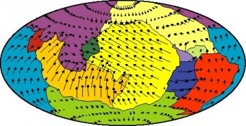
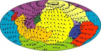
(Top) Observed plate velocities calculated in a reference frame yielding no net global rotation of the lithosphere as a whole. (Bottom) Plate velocities computed by a model in which freely moving plates are coupled to the mantle flow induced by internal masses deduced from global tomographic models. The low-harmonic-degree content of the results yield discordant velocity vectors near the plate boundaries. (Courtesy Claude Froidevaux, Ecole Normale Superieure, Paris.) The commission works to foster communication, interaction, and collaboration among those working in geodynamics and/or tectonophysics, as well as to promote interaction with the other branches of the earth sciences. The comparison and exchange of concepts and techniques of numerical modeling have played an important role at workshops sponsored by the commission. Benchmark solutions for a set of standard problems in mantle convection, which now serve to verify computer codes and estimate their accuracy, are one product of these workshops. Furthermore, the commission has promoted a number of symposia at regular IASPEI meetings that aimed at the interdisciplinary exchange of results and concepts with other working entities of IASPEI.
Computer modeling in the earth sciences has come of age. Large-scale computations, including those in three dimensions, have become standard and are essential for studies in geodynamics and tectonophysics. In the past, the aim of numerical modeling has been mostly to understand processes in principle, without necessarily linking results to specific observations. While that approach will continue to play a role in the future, numerical modeling also has become increasingly a working tool to address concrete geological situations in a realistic way, while using a minimum of ad-hoc assumptions. A major obstacle on this path has been the synthesis of the mechanical concept of plates and the fluid-dynamical concept of mantle convection, but recent progress in this direction is encouraging. To understand the role of plates in large-scale convection and the influence of the global circulation in the mantle on regional lithospheric processes requires a closer interaction of geodynamicists and tectonophysicists. To make computer modeling a working tool for the interpretation of data requires cooperation with specialists from other fields, such as seismology. The commission considers it a major task to encourage and support the growing trend for this kind of collaborative research, according to Uli Christensen (Germany).
The Subcommission on Tomography of the Commission on Wave Propagation
 The Subcommission on Tomography of the Commission on Wave Propagation contributes to the development and implementation of this powerful tool for mapping the detailed structure of the interior. The subcommission is concerned with both the forward problem of wave propagation and the inverse problem of recovering structure from observed data. Tomography, the systematic inversion of seismic travel-time data for internal structure, uses an impressive array of techniques to create spectacular images of the Earth's interior. The interpretation of these images has led to still-primitive, but credible, models of the internal dynamics of the planet. As the global coverage by high-quality seismographic stations improves, there will be a corresponding improvement in the resolution of internal Earth features achievable by tomographic techniques.
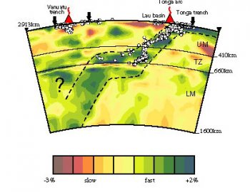
Tomographic image of aspherical variations in P-wave velocity in the mantle below northern Tonga. The complex morphology of the subducting Tonga slab is seen. (From R. van der Hilst, Nature, Vol. 374, 1995.)
IASPEI has worked closely with the International Lithosphere Program (ILP) since ILP began in 1980. This program is jointly supported by IUGG, the International Union of Geological Sciences (IUGS), and ICSU, and is directed by the Inter-Union Commission for the Lithosphere (ICL).
 The long-term goals of the ILP fit well with several of the scientific interests of IASPEI, namely, to understand better the structure, composition, and dynamics of the lithosphere. This understanding is sought both for scientific reasons and for practical applications: response to geologic hazards, development and management of natural resources, and preservation of the environment.
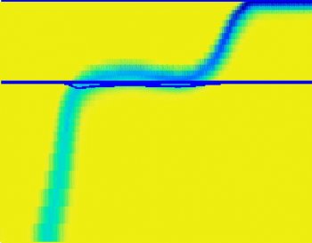
Slab subduction through a phase boundary computed from a geodynamical model showing similar morphology. (U. Christensen, Earth and Planetary Science Letters, Vol. 140, 1996.)
The International Heat Flow Commission
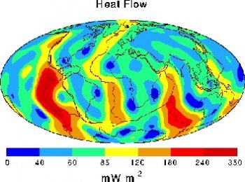
The International Heat Flow Commission (IHFC) is co-sponsored by IASPEI, the International Association of the Physical Sciences of the Ocean (IAPSO), and the International Association of Volcanology and Chemistry of the Earth's Interior (IAVCEI). IHFC promotes, on its own or in collaboration with other organizations, all aspects of geothermal investigations Working groups have focused on developing tools for geothermal researchers. These tools include a heat flow density database, a paleoclimate database, and regional heat-flow maps and atlases. IHFC addresses two major topics of contemporary geothermics: heat-flow studies that suggest correlations with other geoparameters, and borehole observations that may offer a glimpse of past climate. In the heat flow studies, IHFC is particularly interested in one- and two-dimensional geothermal modeling and the structure of the crust and lithosphere. In the climate-related temperature-versus-depth studies, elements of interest include the recovery of information about past climatic conditions, ground surface temperature histories, and air/soil temperature coupling.
"Just as one database was completed, the IHFC began to compile another--this one of subsurface temperature observations and ancillary data relevant to the understanding of the earth's recent surface temperature history. This database is an important component of the International Geosphere-Biosphere Program (IGBP) organized to document global change." V. Cermak (Czech Republic)
Acquisition of density, heat flow, and other geothermal data includes the need to estimate data quality before publishing the data. The IHFC completed a new, revised version of the World Heat Flow Data Collection in 1992. IHFC also cooperates with the International Commission on the Lithosphere (ICL) and the International Geothermal Association (IGA). Specific aspects of geothermal research being explored include developing and recommending standards and techniques to quantify geothermal energy resources and to determine all geothermal parameters such as the thermophysical properties of earth materials, underground temperatures, and heat flow.
Slab subduction through a phase boundary computed from a geodynamical model showing similar morphology. (U. Christensen, Earth and Planetary Science Letters, Vol. 140, 1996.)
The Commission on Physical and Chemical Properties of Materials of the Earth's Interior
The Commission on Physical and Chemical Properties of Materials of the Earth's Interior is an inter-association commission of IASPEI and IAVCEI. Its goal is to encourage and facilitate interdisciplinary research and discussion on the nature and dynamics of the Earth's interior. Understanding of the planet's complex and dynamical nature since accretion is advanced through experimental and theoretical studies of the physical and chemical behavior of Earth materials. A variety of state-of-the-art experimental techniques are applied to the acquisition of data under ambient conditions approximating those in the Earth's interior. Such studies provide constraints on the structure and composition of the planet's interior and characterize the important physico-chemical exchanges between the metallic core, the silicate mantle and crust, and between the atmosphere and hydrosphere. New understanding of earth processes and evolution will only come about through a strong interdisciplinary approach to the characterization of the nature and dynamics of the minerals and melts that are the fabric of the deep Earth. 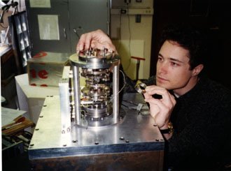 Moreover, by promoting interdisciplinary research and discussion, the commission aims to bring forth a greater appreciation of the data and uncertainties in the measurements and models of the Earth's interior made by geophysicists and geochemists. A major task of the commission is to coordinate international symposia and workshops that will promote the discussion of such interdisciplinary studies of the Earth's interior.
"In the next few years, it is likely that an effort will be made to generate new reference Earth models and such models will not be solely seismological. Mineral physics and chemistry, geodynamics, and geomagnetism will also be important." G. Masters (USA)
Laboratory measurements of wave attenuation in mantle-like materials and the resulting velocity dispersion at seismic frequencies (0.001 to 10 Hz) are essential for interpreting seismic wave data in terms of the composition and properties of the interior of the Earth. (Courtesy Hartmut Spetzler, Rock Physics Laboratory, University of Colorado.)
IASPEI Serves Regional and Other Special Needs
In addition to activities focused on specific scientific topics and infrastructure needs, IASPEI supports the activities of several commissions and committees created to serve broader needs of the seismological community. Some of these have a regional focus, others address more general needs.
The European Seismological Commission
The European Seismological Commission (ESC), formally created by IASPEI in 1951, promotes seismological research in Europe. The motivation of European seismologists that led to the ESC can be traced back at least to 1901, when the first International Seismological Conference met in Strasbourg. The 38 Member Countries of ESC include all those near the Mediterranean Sea and encompass the area from the Mid-Atlantic Ridge to the Ural Mountains and from the Arctic Ocean to North Africa. Gennadi Sobolev (Russia) explains, "Each country that adheres to IASPEI and is situated within the European-Mediterranean region is a member."
Scientific activities of the ESC include the seismicity of the European region, data acquisition and analysis, earthquake source physics, problems of earthquake prediction, strong and weak earthquake ground motions, deep seismic sounding and the three-dimensional structure of the European lithosphere-asthenosphere system, and engineering seismology. This work is carried out through six subcommissions, each with appropriate working groups.
The European Seismological Commission
The Asian Seismological Commission (ASC) recognizes the high seismicity and very large population that combine to create the earthquake risk in Asia and the need to improve cooperation among Asian and Pacific nations to mitigate the catastrophic effects of large earthquakes. Delegates from 11 Asian and Pacific countries were represented at the meeting convened in Guangzhou, China, in April, 1995 at which statutes for the proposed Commission were drafted and later adopted. The first activity of the Commission was the subsequent convening of a IASPEI Regional Assembly in Tangshan, China.
Harsh Gupta (India) explained that in its efforts to increase priorities for earthquake disaster mitigation, ASC focuses on regional seismological interests, earthquake precursors, earthquake hazard assessment, strong-motion seismology, and the impacts of earthquakes on society. Some nations in the region have already established high-quality observational networks. In China, for example, a test site along the Red River fault system includes on-line recording seismic stations combined with regular geodetic and electromagnetic surveys and water chemistry monitoring.
The International Commission on Earth Sciences in Africa
The International Commission on Earth Sciences in Africa (ICESA) is an independent body that has commission status in IASPEI and is vigorously supported by it. ICESA was created to facilitate and coordinate geoscientific work in Africa, with a strong emphasis on the training of earth scientists and exchanges of personnel and ideas among the member countries. Isaac Nyambok (Kenya) explained that "To achieve our objectives, ICESA initially identified two core research projects and three working groups." The research projects focus on rift systems in Africa and African-Eurasian plate interactions. Working group interests include Precambrian evolution and metallogenic provinces in Africa, geoscientific data acquisition and exchange of information, and regional seismological networks.
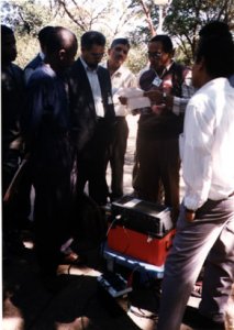
An example of IASPEI-promoted geoscientific work in Africa is an effort of the Commission on Earthquake Hazard and Prediction to fully instrument and understand how a specific volume of rock is affected by seismic events. An experiment was proposed for the gold fields of South Africa. Blasting occurs there almost daily, with subsequent swarms of seismic events, some as large as magnitudes 3.5 and 4.0, as brittle fractures propagate through the strong quartzite toward undisturbed rock. This experiment offers valuable information to many related experimental fields besides seismology, including rock mechanics, nonlinear continuum mechanics, fractal analysis and pattern recognition, potential field signatures in noisy environments, and gaseous geochemical tracers.
A group of young seismologists receives a lesson in seismographic techniques at a workshop in Ethiopia organized by the Eastern and Southern African Working Group, sponsored by the Committee for Developing Countries. (Courtesy R. Adams.)
The Committee on Education
The Committee on Education was established in 1996. Its primary charge is "to promote the transfer of technology to developing countries and to ensure the continuation and coordination of training courses." Although earthquakes continue to inflict high levels of destruction around the world, good progress is being made in hazard assessment and mitigation techniques to protect lives and property. The issue is how to put recent advances into practice, especially in developing countries.
This recently formed committee is now organizing two activities, according to W. H. K. Lee (USA). The first is an encyclopedia of seismology (including earthquake engineering) that will summarize present knowledge, especially with respect to hazard assessment and disaster mitigation techniques. The second initial project is the co-sponsorship of training courses in modern seismic instrumentation, data processing and analysis. The Committee welcomes interested persons to participate in its activities and will assist organizations in planning an earthquake hazards mitigation program.
The IASPEI Committee for Developing Countries
In 1991 the Executive Committee of IUGG decided that service and communications to developing countries could be provided best through the individual Associations rather then by a centralized committee of the Union. The IASPEI Committee for Developing Countries (CDC) was formed in response to this decision. The initial efforts of the Committee were tied closely to the IDNDR, which was getting underway at about the same time the Committee was formed. The first emphasis has been on seven selected activities:
- Recommendations on improvement of seismological recording networks.
- Promotion of hazard assessment studies in support of GSHAP.
- Support of IHFC efforts to hold a workshop on geothermal studies for developing countries.
- Collaboration in support of a training course with ISOP and with continuing courses in several countries.
- Establishment of a mechanism for exchange of publications (see section on Publications, below).
- Participation in regional seismological assemblies.
- Coordination of IASPEI financial support for scientists from developing countries to attend IASPEI assemblies.
The Committee also publishes a biannual newsletter containing information of particular interest to developing countries.
Publications, Education, and Training
IASPEI educational and training efforts are on-going and address specific needs of the seismological research community. Much of the activity during IASPEI General Assemblies has a strong education component, especially workshop activities. Many other training and education efforts, some of which have been described above, are carried on outside of the General Assembly framework.
IASPEI publications include newsletters, monographs, and proceedings. Among the serial publications is the IASPEI Newsletter prepared by the Secretary-General to disseminate reports by IASPEI Commission Chairs, meeting organizers, and others involved in IASPEI-sponsored activities. The Committee on Developing Countries Newsletter provides a forum for exchanging news and views of geophysical importance among geoscientists, particularly those from developing countries. These scientists are encouraged to contribute news items such as regional projects, meetings, training courses, network development, and reports of significant geological events. The IDNDR Newsletter highlights IASPEI/IDNDR activities. A version is printed in Chinese.
The proceedings of many IASPEI-sponsored symposia are published as special issues of scientific journals with international readership. All papers accepted for these publications undergo standard peer review and must meet customary professional standards.
As part of IASPEI's outreach effort, the publication transfer program of the Committee for Developing Countries makes available basic texts and publications on seismology and related earth sciences to institutions in need. The IASPEI Secretary-General serves as a clearing house for requests and offers. Institutions who have publication needs, as well as those with surplus publications, including back runs of journals, should send a list to the Secretary-General. Requests for payment or reimbursement of reasonable shipping costs can be made to IASPEI.
International Cooperation for Better Understanding of the Earth
 The organizational structure and the scientific programs of IASPEI have been created around a central concept: international cooperation is the sine qua non for the advancement of seismology and the physics of the Earth's interior. The contributions to human welfare and knowledge of the many collaborative research projects and of the dissemination of the results of research to the international community through activities promoted by IASPEI are testimony to the effectiveness of IASPEI in pursuit of its goals.
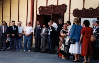
Seismologists of the world gathered in New Zealand in a spirit of friendship and cooperation for the 1994 IASPEI General Assembly. (Photograph courtesy E. R. Engdahl.)
IASPEI depends for its future success on the vigorous support of the individual scientists who plan and perform the research, deliver the reports on their findings at IASPEI-sponsored symposia, and devote countless hours as volunteers to the work of commissions and workshops. But IASPEI also relies on the support of the Member Countries, which provide the core financial and intellectual support, and on the National Committees that represent these Members in IUGG and IASPEI. Nations that are affected by damaging earthquakes obviously benefit from the work of IASPEI. However, all nations benefit because this work extends the scope of human knowledge and the applications of that knowledge to other problems, such as the location and development of natural resources and the preservation of the natural environment.
The Associations of IUGG
- International Association of Geodesy
- International Association of Seismology and Physics of the Earth's Interior
- International Association of Volcanology and Chemistry of the Earth's Interior
- International Association of Geomagnetism and Aeronomy
- International Association of Meteorology and Atmospheric Sciences
- International Association of Hydrological Sciences
- International Association of the Physical Sciences of the Ocean
Commissions, Committees, and Affiliated Activities of IASPEI
- Commission on Practice
- Commission on Earthquake Hazard and Prediction
- Commission for International Decade of Natural Disaster Reduction
- Commission on Wave Propagation
- Commission on Controlled Source Seismology
- Commission on Geodynamics and Tectonophysics
- International Heat Flow Commission (joint with IAVCEI and IAPSO)
- Commission on Physical and Chemical Properties of Materials of the Earth's Interior (joint with IAVCEI)
- Committee on Volcano Seismology (joint with IAVCEI)
- European Seismological Commission
- Asian Seismological Commission
- Committee on Education
- Committee for Developing Countries
- International Commission on Earth Sciences in Africa
- Federation of Digital Broadband Seismograph Networks
- International Ocean Network
Acronyms
- ASC Asian Seismological Commission
- CCSS Commission on Controlled Source Seismology
- CDC Committee for Developing Countries
- CERESIS Regional Centre for Seismology in South America
- ESC European Seismological Commission
- FDSN Federation of Digital Broadband Seismographic Networks
- GPS Global Positioning System
- GSHAP Global Seismic Hazards Assessment Program
- IAEE International Association of Earthquake Engineers
- IAPSO International Association of Physical Sciences of the Ocean
- IAVCEI International Association of Volcanology and Chemistry of the Earth's Interior
- ICESA International Commission on Earth Sciences in Africa
- ICL Inter-Union Commission on Lithosphere
- ICSU International Council of Scientific Unions
- IDNDR International Decade for Natural Disaster Reduction
- IGA International Geothermal Association
- IGBP International Geosphere-Biosphere Program
- IHFC International Heat Flow Commission
- ILP International Lithosphere Program
- ION International Ocean Network
- ISC International Seismological Centre
- ISOP International Seismological Observing Period
- IUGG International Union of Geodesy and Geophysics
- SSA Seismological Society of America
- STEND System for Technology Exchange for Natural Disasters
- WWSSN World-Wide Standardized Seismograph Network
Credits
Contributions to the brochure came from many sources, especially the IASPEI Commission and Committee Chairs serving in 1996-97, supplemented by valuable suggestions from the IASPEI Bureau and a number of individual scientists. A first draft text, synthesizing the original input material, was prepared by Dr. Joann Dennett, University of Colorado. Responsibility for writing the final version was entirely that of Dr. Carl Kisslinger, University of Colorado, past IUGG Vice-President and longtime IASPEI supporter. Dr. E. R. Engdahl, IASPEI Secretary-General, assembled the figures with help from many scientists worldwide who are acknowledged in the figure captions. Marilee DeGoede arranged the layout and the printing under the direction of Dr. Kisslinger. Finally, we are very grateful to our corporate sponsor Quanterra, Inc. for funding the publication of this brochure.